 |
| We weren't able to make a campsite reservation (well we had one but it was cancelled because of COVID-19) so we planned on wild camping in forest somewhere. But we found a private campground at the far end of Twin Lakes outside Bridgeport, CA. Here's the view at sunset as you drive west towards Twin Lakes. |
 |
| The view towards the west of Twin Lakes with the Mono Village campground in the distance. |
 |
| We were lucky in that right as we arrived, the campground opened up a section that was in the trees and along the river. Secluded and quiet. Perfect. |
 |
| Just hanging out and this guy walks by to munch on some grass! |
 |
| We camped for four nights and on the last night, our friend Mary (and some of her friends) joined us! |
 |
| This photo taken by Mary's friend in portrait mode clearly shows that the camera on my iPhone 7 is inferior. |
 |
| Here's the view towards the north end of the Owens River Valley, looking into Nevada |
 |
| Post Buckeye Hot Springs....feeling h |
 |
| We spent an afternoon at Convict Lake just south of Mammoth. |
 |
| Of course I took a dip. Always. |
 |
| Someone loves their phone. If I did this, I would definitely drop my phone in the water. |
 |
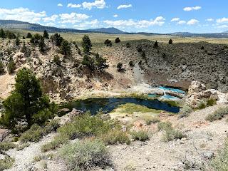
| Over on the other side of the valley is this beautiful blue hot spring. |
 |
| No entry....apparently the water can be excessively hot and there have been deaths. |
 |
| Since we LOVE to just drive, we got in the car one day and drove the three hours (one way) to Death Valley. |
 |
| As we were approaching the valley, we began to see Joshua Trees. |
 |
| Starting the descent into the first valley in the park...here is one of the side canyons. |
 |
| And there it was....Panamint Valley, which is still at 2,000 feet above sea level. |
 |
| Panamint Valley |
 |
| Dusk in the Eastern Sierra. As always, stunning. |


1 comment:
If it makes you feel any better Mr Chen, my family drove 8 hours to go to Dairy Queen 3 weeks ago...
Post a Comment